
Patricia sent me this link of Ohio as a piano. Andy Woodruff at the Cartogrammer.com blog has seized on the coincidence that there is exactly one Ohio county for each key on a piano and mapped the sounds to the map so that clicking or mousing over a county plays that note.
Where it gets interesting is that you can remap the sounds, according to the available GIS data. Low values play low notes, high values play high notes. Most of the music is too John Cagish for my taste, but I liked the Crop Acr97 mapping, where you can literally hear Ohio grow more farmable as you move southeast - northwest. 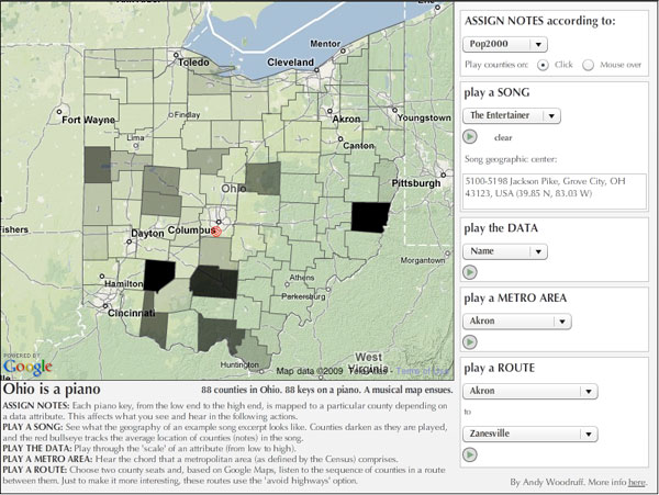
Saturday, October 10, 2009
Labels:
cartography,
music,
technology
![]()
![]()
Subscribe to:
Post Comments (Atom)

1 comment:
Greater numbers of farms in a county in Ohio seems to correlate pretty well with terminal moraines. Terminal moraines are made of rich soil, but they are difficult to build roads through and difficult to farm because of their hilliness. Which means small farms are rather more sustainable in counties with terminal moraines. There are a number of counties with a high number of farms between Brunswick and Zanesville, and in the 2 large middle counties on the Indiana border. There are terminal moraines in all of these counties. These counties are not in the southeast (which has poor farmland and is very hilly), nor in the northwest (where flat terrain makes large farms profitable). Many other counties also have terminal moraines in them. They usually sound higher in pitch (greater number of farms) than those that do not have terminal moraines - unless they have become quite urban. Of course, cities are usually built on good farm land, eventually squeezing out the farms.
There is something else that consists of 88 pieces besides the piano keyboard and the counties of Ohio. I forget what. Do you know?
Post a Comment